Monday, July 25, 2011
Tye River Valley
This USGS map shows the Tye River Valley with Alpine (on the right) and property the Alpine Lumber Company owned (in the center). The yellow circles correspond approximately to the photographer's position in the photos below.
Lee Pickett photo looking east down the valley in 1931. The Stevens Pass Highway is on the right and runs diagonally to the center of the picture where it curves around the base of the the hill. On the left there is a bridge crossing the Tye River. This view includes Sections 28 and 29 where the Alpine Lumber Company owned property so the bridge may have been for their logging railroad. The Company started a camp in September 1919 in Section 28 but there don't appear to be any buildings in any of these photos. Alpine is about three miles from here, right center of the photo on the mountain in the background.
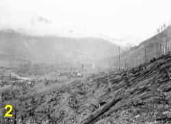
Another 1931 photo looking east, the Stevens Pass Highway is on the left and runs diagonally to the center of the photo. The Great Northern Railway tracks are on the right, half way up the mountain.
Looking northwest from Great Northern Railway bridge 413 at Mile Post 1726.3 in 1933.
Looking west down the valley in 1931.The Stevens Pass Highway is at left center, Great Northern Railway tracks are on the left.
View to the southwest from Embro, the old Great Northern depot at mile post 1715. Alpine is across the valley on the right, below the tops of the fir trees in the foreground.
Subscribe to:
Post Comments (Atom)


I really like Embro Great examples of tunnels and snowsheds. Great view of Alpine.
ReplyDelete