The Skykomish Historical Society has some aerial photos of the Tye River Valley from 1930, you can search "alpine" on the photo collections page to find them. Bob Kelly at the museum gave me some very large size photos and today I made a trip to an area east of Alpine Falls to try and locate a section of the Alpine Lumber Company logging railroad that appears in one of the photos. Here is an overview of the 1930 area with some landmarks.
Here is a modern map showing the same area.
I drove up the Old Cascade Highway and found the railroad grade intersected with the highway and followed it to where it once crossed the Tye River. At the bottom of this picture you can see a Great Northern train going through the Bonneville Cut east of Alpine.
The bridge crossed the Tye River here. Highway 2 is on the left. The river is only about 25 feet wide here, it flows through a narrow channel between two very large rock formations.
I know the 1891 Great Northern horse pack trail was in this area, near Scenic it was north of the Tye River, at Alpine Falls it was on the south side. I figured this was a good place to cross so I backtracked up the railroad grade and started looking for a road east of the railroad. I found this and followed about a thousand feet east.
This probably continued on to Martin Creek City, a collection of cabins built during construction of the Martin Creek bridge and tunnel. Photo is from the Skykomish Historical Society.
Keesha picked up a scent as soon as we got out of the car.
I was prepared to meet a foraging bear but this 10 point buck almost ran into us a few minutes later.
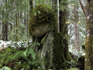
I don't know how this happened, a very large rock balanced on a cedar stump. The rock has protected the top of the stump from the weather, there are still ax marks visible on the under cut so the rock has been there since shortly after the tree was cut down.


