Monday, July 25, 2011

Tye River Valley


This USGS map shows the Tye River Valley with Alpine (on the right) and property the Alpine Lumber Company owned (in the center). The yellow circles correspond approximately to the photographer's position in the photos below.


Lee Pickett photo looking east down the valley in 1931. The Stevens Pass Highway is on the right and runs diagonally to the center of the picture where it curves around the base of the the hill. On the left there is a bridge crossing the Tye River. This view includes Sections 28 and 29 where the Alpine Lumber Company owned property so the bridge may have been for their logging railroad. The Company started a camp in September 1919 in Section 28 but there don't appear to be any buildings in any of these photos. Alpine is about three miles from here, right center of the photo on the mountain in the background.


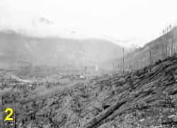
Another 1931 photo looking east, the Stevens Pass Highway is on the left and runs diagonally to the center of the photo. The Great Northern Railway tracks are on the right, half way up the mountain.


Looking northwest from Great Northern Railway bridge 413 at Mile Post 1726.3 in 1933.


Looking west down the valley in 1931.The Stevens Pass Highway is at left center, Great Northern Railway tracks are on the left.


View to the southwest from Embro, the old Great Northern depot at mile post 1715. Alpine is across the valley on the right, below the tops of the fir trees in the foreground.

Friday, July 15, 2011

July 10 Visit to Alpine

Alpine, WA July 15, 2011.

A few of us were at Alpine last weekend, I haven't had time to work on any photos yet. We staked out three corners of the sawmill, shown on this map as red circles:


The red x on the map is approximately 30 feet north of the railroad signal.

We scaled off the map and used the creek as a reference point so the stakes may be 10 or 20 feet off from where the mill actually was. We hung some paper plates from the trees above each stake if anyone is interested in looking at our work.


I just completed a CD with 35 pictures of Alpine, available in two styles: Mod and Ultra Mod, both free of charge. It includes all the maps you have seen on this blog, some old photos, modern photos and an introduction written by Tim Raetzloff, Senior Fellow at the planned-for Alpine Foundation. Using the information on this CD you can find the place, navigate around town, locate old buildings, and so on and so forth. If you want one send me your name and address and I will mail it to you.

mattcawby@gmail.com

Thursday, July 7, 2011

The Shingle Mill

Alpine, WA July 7, 2011.

The Alpine Lumber Company shingle mill was a couple of hundred feet east of the lumber mill, it is the small building in the foreground in this photo. The smokestacks at the mill are about where we have excavated some of the concrete mill foundation.


The 1919 Annual Banquet and Dance book has a list of the mill equipment that includes one Sumner upright shingle machine, probably housed inside this building.


The Sumner Iron Works produced three models of upright shingle machines: the Standard that cut 16" shingles, the High-Standard that cut 16" and 18" shingles, and the Gold Medal that cut 16", 18", and 24" shingles. Pictured here is the Gold Medal, the Alpine mill may have used a different model though.


In June we found a concrete thing near the shingle mill, this may have been a base for the engine that powered the shingle machine. The floor would have been 8 or 10 feet above the engine and it was probably connected to the shingle machine by a belt. In this photo we are looking west toward the lumber mill. The concrete foundation of the mill is about 200 feet in the distance.


The Sumner Iron Works was in Everett and produced sawmill and logging equipment. The Nippon Lumber Company owned one Sumner roader, a steam donkey with a horizontal boiler. Acrowood Corporation, a manufacturer of forest products equipment, now occupies the old Sumner Iron Works factory at 4425 South Third Avenue in Everett.

Tuesday, June 28, 2011

Alpine Falls

Alpine, WA June 28, 2011.

Today I visited Bob Kelly at the Skykomish Historical Society and we discussed the Alpine photo history CD. In the afternoon I went to Alpine Falls looking for a trail shown on this 1936 map:


Map is from Historic Map Works.

No sign of the trail after a couple of hours of brush whacking. Headed back to the truck, parked at the site of the historic Alpine Falls House of Souvenier. The house is gone, but not the outhouse. It's just a short but dangerous walk away across Highway 2.


Here is a video of Alpine Falls.


Keesha was pretty tired so we headed back down to the lowlands.


Thursday, June 23, 2011

Carl Clemans and Family

Today I was in Snohomish and stopped by the Grand Army of the Republic Cemetery to locate the grave of Carl Clemans, patriarch of the Alpine Lumber Company. Tim had been there a few years ago and gave me directions; drive past the office and on the gravel road, to the left. I was pretty close but was unable to find the markers so I called Tim for more detailed directions. Look around the maple tree he said.

Ah, there they are.


On the right: Carl Lane Clemans Jr. Feb. 28, 1907 - Jan. 1, 1908
Carl Lane Clemans 1873 - 1941
Harriet Smith Clemans 1878 - 1961


The Clemans family lived in Snohomish, at 315 Avenue C.


Thursday, June 2, 2011

June 1st Discoveries

Alpine, WA June 1, 2011.

On Wednesday, June 1 we cleared some brush at the saw mill in the area on the map with the blue and red marks. This is a rough estimate on the location since we don't have many reference points yet except the west end of the mill, sort of.


We found this thing, represented by the blue mark on the plan, two concrete pads with a some timbers in between. At ground level the wood is preserved quite well, the top part has rotted away but judging by the bolts still in place it was probably about 24" off the ground.


Looking east, the railroad tracks are about 100' to the right. It kind of looks like the concrete anchored the timbers and maybe used as pier pads for posts.


The piece of wood between the concrete is still solid. There was a fire here at one time, lots of charcoal in this area.


11 feet west of our first discovery was a concrete block, measuring 77" x 30". This is shown in red on the saw mill plan.


No anchor bolts in this one, there was a masonry cap on top, probably for leveling purposes.


The Alpine depot was at mile post 1723.5, at 1723.9 is Great Northern Railway Bridge 406, built in 1902. I got some pictures of the bridge from below, don't try this at home though, very steep terrain.


Keesha likes to do the scary wolf routine when we are in the woods.


At the end of the day, we packed up our toys and stopped to admire our work as a westbound train came down the hill. Not just any train, the first car was carrying a 737 fuselage from Wichita to Renton. Unfortunately, we were out of position to get a picture and the cameras were already put away, so we high tailed it down to Skykomish in hopes of getting set up for a good shot when the train came through town. We made it with time to spare.


Sunday, May 22, 2011

Alpine Visit May 22

Alpine, WA May 22, 2011.

On Sunday we wanted to see if there were any remains of the water tank shown on the 1927 map. A.F.E. 11554 2-28-1920, a 50,000 gallon tank 60 feet from center of the track.


We scored huge.


On the right you can see the supply main from the creek, a 6" wire wound wood pipe.


We spent some time digging around the saw mill foundation.


This light bulb was under a piece of metal.


A Patterson's Tuxedo Tobacco tin was a few feet away from the light bulb. It was completely covered with tar that probably inhibited corrosion.


Donna found this concrete thing east of the saw mill. It measures 26" x 84" and has six anchor bolts on top.


It is in the vicinity of the shingle mill, a small building, 25' x 28'. The south side was 122' from the tracks. Our concrete thing was 125' from the tracks.


Looking west, the saw mill was about 200' in the distance.


The concrete block is down the bank, about 10 feet below the tip of the arrow. The red line is the approximate location of the Alpine Lumber Company railroad spur. There was a platform extending about 40 feet from the railroad spur, over the bank. Photo was taken near the tracks next to the signal.